


GPS Distance Land Area Measure
Description of GPS Distance Land Area Measure
GPS Distance Land Area Measure is an application designed for users who need to calculate distances and areas with precision. This app allows individuals to measure land areas and distances using both GPS and manual methods. Users looking to download GPS Distance Land Area Measure for the Android platform can find it easily through various means.
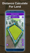
The primary function of this app is to provide accurate measurements of any specified area on a map. By utilizing the user's current location, the app enables measurements of land areas simply by selecting the desired area on the map. Users can click on the map to place markers, making it straightforward to determine the size of various locations.
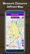
One of the essential features of the GPS Distance Land Area Measure app is its ability to calculate the distance between multiple points on the Earth's surface. Users can select specific locations and measure the distances with ease. This function can be particularly useful for anyone needing to assess distances for travel, land planning, or recreational activities.
The app's interface is user-friendly, allowing even those unfamiliar with mapping tools to navigate it effectively. Users can zoom in on specific locations for a closer look, ensuring they can accurately mark the points they wish to measure. If any mistakes are made during the marking process, the app simplifies corrections by allowing users to delete misplaced points quickly.
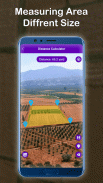
The GPS Distance Land Area Measure app also features a Land Area Measure tool, which makes it easy to determine the ideal size for any land area. This tool is designed for efficiency, allowing users to assess land quickly without needing complex procedures. It supports both manual measurements and GPS methods, which enhances the accuracy of the results.
Saving measurements is made convenient through the app's intuitive design. After completing a measurement, users can enter a name and description for the measurement field. Additionally, there is an option to enhance saved measurements by adding images taken from the camera or imported from the gallery. This function is beneficial for users who want to keep track of their measurements visually and descriptively.
Another functional aspect of the app is its capability to locate Points of Interest (POI). Users can select locations and instantly receive the latitude and longitude of those points. This feature is particularly useful for individuals who need precise geographic information for navigation or planning purposes. The ability to save these POIs also adds to the app's practicality.
The app includes various map types, allowing users to switch between normal, satellite, terrain, or hybrid views. This flexibility enables users to choose the view that best suits their needs for measuring distances or areas. The real-time measuring and calculating capabilities further enhance the user experience, allowing for immediate feedback on measurements taken.
Users can easily move and drop points on the map with simple touch gestures. This touch functionality ensures that adjusting markers is straightforward and does not require complex actions. The app's design caters to an efficient measuring process, making it suitable for both casual users and those needing precise measurements for professional purposes.
GPS Distance Land Area Measure offers a complete toolkit for anyone needing to measure distances or areas. Its combination of GPS and manual measurement methods provides users with accurate results that can be tailored to specific needs. The app's ability to save and edit measurements, along with its user-friendly interface, makes it a valuable tool for various applications.
The app also supports the discovery of distances between two places, further enhancing its utility for users involved in travel or logistics planning. The ability to calculate areas and distances accurately contributes to effective land management and personal planning.
In essence, GPS Distance Land Area Measure is a practical application for those requiring reliable measurements of land areas and distances. Its range of features, including the ability to save measurements, locate Points of Interest, and switch between different map types, ensures that users have the tools necessary for precise measurement tasks. The app’s straightforward functionality makes it accessible to a wide range of users, from casual individuals to those in need of professional-grade measurements.
By downloading GPS Distance Land Area Measure, users can take advantage of its comprehensive measurement capabilities, making it an essential app for anyone involved in land assessment or distance calculations.
GPS Distance Land Area Measure - APK Information
APK Version: 13.0Package: alana.maparea.measure.geoLatest Version of GPS Distance Land Area Measure
Other versions


 3.99
3.99

Apps in the same category


